In his prescient work, the computer scientist-turned-author envisioned the world of tomorrow — a world where physical reality is represented, perfectly, in digital form; a living document detailing in real time every nuance of the communities in which we live.
What exactly is a Mirror World? Quoting from Gelernter’s seminal work:
They are software models of some chunk of reality, some piece of the real world going on outside your window. Oceans of information pour endlessly into the model (through a vast maze of software pipes and hoses): so much information that the model can mimic the reality’s every move, moment-by-moment. A Mirror World is some huge institution’s moving, true-to-life mirror image trapped inside a computer — where you can see and grasp it whole. The thick, dense, busy sub-world that encompasses you is also, now, an object in your hands.
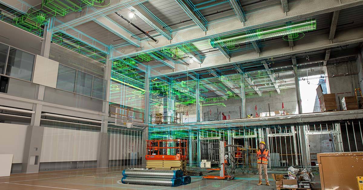
Thirty-two years later, for all practical purposes, we are living these predictions. Thanks to 3D laser scanning technology, static terrestrial, and SLAM-based mobile (simultaneous localization and mapping) every day, millions of physical assets around the world —manmade or natural —residential and commercial buildings, power plants, industrial facilities, and subterranean environments like mines, are being turned into virtual models of digital data.
Two Roads, One Path
But in the nearly 60-year history of terrestrial (static, or fixed position) laser scanning and the somewhat shorter history of mobile scanning, (on-the-go reality capture) the two related but different technologies began charting separate paths.
Company’s building terrestrial laser scanners (TLS) boasted of the technology’s increasing accuracy and precision, with applications ranging from reverse engineering and quality control, to forensic analysis for public safety, to point cloud-based modeling for the architecture, engineering and construction industry. Mobile scanning companies, aware of their products’ data granularity limitations, instead promoted their technology’s speed of data capture, ease-of-use, cost savings, and mobility, so that project management/oversight in construction and infrastructure projects, as well as mining operations, could continue with maximum efficiency yielding reduced completion time and realized results.
While not a literal industry slogan, mobile scanning increasingly took on the mantra of “don’t let perfection be the enemy of the good.” For many projects, the argument goes, a high-speed, lower resolution mobile scan was more than good enough.
Today, however, these once-divergent roads are linking up. It’s a transformation led by innovative companies on both sides of the reality capture industry and it’s happening for two reasons:
- The realization that especially in AEC and mining applications — convergence analysis, production progress mapping, vertical shaft inspection, stockpile volume, geological mapping, and design and planning — that the mobile versus static bifurcation has proved more nuanced; there are in fact many examples where both high-resolution terrestrial scans and fast lower-resolution mobile scans are useful in a single project.
- Advances in SLAM-based software algorithms, data processing speeds, and online and offline workflows, are helping bring static and mobile scanning technology into unified hardware and software systems — in these scenarios mobile scanning devices are essentially doing “double duty” bringing the best of both worlds together
In other words, “good enough” may still be “good enough” for the vast majority of mobile scanning applications. But when the technology does fall short, or a specific use case arises within a mining or AEC project (and others, as will be discussed in follow-up articles) static scanning can complete the data picture, filling in gaps that a mobile scan may miss.
Examples for these types of applications are varied. For AEC, as with mining, production progress mapping/project oversight is particularly important. Both industries have numerous stakeholders involved, and many of these stakeholders are located thousands of miles away from a project site or mine. A SLAM-based mobile scan can capture a large volume space, without the need for GPS triangulation with good enough quality, and provide a necessary overview of where a project stands.
The way it works is simple: point clouds are processed in a software program and compared against earlier scans, or to CAD models. Once complete, a digital file is generated (often in simple PDF format) where it is sent to those stakeholders. While a traditional static 3D laser scanner can accomplish this aim (and accomplish it with extreme fidelity) a mobile scanner can do it well enough, at a more competitive price point, and at much faster speeds, which can accelerate an entire build. This is the essential argument for mobile scans. Why use the $750 Damascus steel steak knife set you received as a wedding gift (or even the $500 set you bought for your new grill) when the stainless steel knife from IKEA does just as well?
But within that same hypothetical project, there are areas where a static scan, aka, the “wedding gift knife,” or even the “grill knife” makes the most sense. This is often evident in MEP (mechanical, electrical and plumbing) applications. Here, the granularity needed to capture all the detailed piping within a building, or self-contained in an MEP room exceeds the capabilities of a mobile scan. This is where a terrestrial laser scanner — or something close — makes the most sense.
The same holds true in mining applications. While a mobile scanner might be great for the above mentioned convergence analysis, production progress mapping, vertical shaft inspection, and stockpile volume, the technology is less ideal for when a project calls for a detailed analysis of the structure and configuration of a particular geological formation. Likewise for mine design and planning, ensuring that new tunnels, ramps, and excavations align with existing infrastructure and geological features.
The Timeless Wisdom of “Two for the Price of One”
Of course, one question naturally comes up. If the mobile scanning and terrestrial scanning worlds are beginning to see themselves less as “frenemies,” (amicable competitors, if you prefer) and more like genuine partners, what’s stopping architects, engineers, miners and leaders from other industries from buying a state-of-the art SLAM-based mobile scanner and a top-of-the-line static 3D laser scanner?
The short answer is: nothing. For the right use cases, sometimes standalone mobile scanners and standalone laser scanners are, in fact, the right tools for the right job — even if simple math says that’s “two for the price of two.”
But as both technologies’ have continued to advance, increasingly what the market will see are “merged” devices — mobile scanners that include static scanning capabilities — even if those capabilities might not fully replace a TLS. (At least not yet.)
The benefits of such a hybrid device are clear. A mobile scanner that can take in-motion as well as high-quality static scans will:
- Reduce the cost of purchase — Literally two devices for the price of one.
- Streamline a company’s laser scanning arsenal — One device that does it all, most of the time.
- Increase mobility of use — For hard-to-reach locations like subterranean environments or dense forests with thick overgrowth and undergrowth — even dropped ceilings in an office.
- Simplify software systems — So that only one software is required to handle all the incoming data processing, storage, filtering, and registration needs.
- Decrease on-site weight and bulk — Leading to fewer injuries, greater scanning agility (with modern handheld or pole-mounted mobile scanners, users can walk at pace-normal speeds capturing as they go. And, depending on the quality of data on-site users are looking to capture, sometimes considerably faster).
- Speed project completion — By saving time (up to 10X faster than traditional TLS) and money, thanks to reduced on-site visits, fewer personnel, minimized materials waste, and faster approval processes. With such a device, environments that would have taken weeks to survey, now only take days.
Thus, terrestrial laser/mobile scanning and its attendant hardware and software applications, is not only groundbreaking in its own right, but is becoming foundational to how the world collects, processes, and shares data. This is especially true in AEC and mining applications, where both static and mobile scanning continues to prove its worth. But it’s also the case in other sectors, including: education, security and defense, utility and power generation companies, government, and transport and logistics services — all topics for future articles.
As the frontiers of SLAM-enabled and LiDAR-based precision measurement systems continue to advance, it will be incumbent on the manufacturers — and purveyors — of this technology to explain the complex fundamentals that underwrite the world’s ongoing digital transformation.
In his 1995 book “A Demon Haunted World: Science as a Candle in the Dark”, the late Carl Sagan, astronomer and gifted popularizer of science may have said it best: “don’t talk to the general audience as you would your scientific colleagues. There are terms that convey your meaning instantly and accurately to fellow experts. You may parse these phrases every day in your professional work. But they do no more than mystify an audience of non-specialists.”
Luminaries like Sagan and Mirror Worlds author David Gelernter got it right. Only time will tell if 3D laser scanning developers and their customers did too. Consider this article the opening salvo in a rich and exciting discussion about where the future of same-device hybrid static/mobile scanning technology will take us.
Or as Gelernter so eloquently put it:
“Technology is the ocean on a bright cool Spring day. Sparkling in the distance; breathtakingly cold; exhilarating once you’ve plunged in.”
Let’s “plunge in,” together.