Case Study

Replace your total station with a 3D Laser Scanner

Replace your total station with a 3D Laser Scanner

CASE STUDY: Comparing the Benefits of 3D Laser Scanning vs. Total Stations

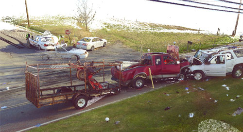
Over the years, many crash and crime scene investigators have embraced the total station; a device used by land surveyors to capture distance and slope measurements of individual points. But now, investigators are putting their old total stations in the closet and adopting a new method of capturing measurements at crash and crime scenes - 3D laser scanners.

Assistant Chief Bobby Jones, a 30-year veteran of the Knox County Sheriff’s Office in Tennessee, is one of those investigators. Chief Jones recently stated, “[Laser] scanners are going to become a way of life for all of us investigators. They’re accurate, reliable, efficient and NOW they are affordable.” Jones has used total stations to map hundreds, if not thousands, of crash and crime scenes. In 2013, Jones gained access to a FARO® Focus 3D Laser Scanner, and it changed the way he gathers data at crash and crime scenes forever.

Case Study
Public Safety Analytics
Crime Scene Investigation
Crash Reconstruction
Law Enforcement
3D Scanners
Focus
Collection
Consideration

Subscribe to our newsletter to stay up to date.

Related Content

Filters

Filters

CASE STUDY

How a German Heavy Transport Manufacturer Uses 3D Scanning

Discover how Germany’s Scheuerle Fahrzeugfabrik, a heavy-load transportation specialist, employs both the FARO® Focus Laser Scanner and Vantage Laser Tracker to aid in its assembly workflows.
비디오

Pratt Miller가 3D 기술을 활용해 차량 개발을 개선한 방법

Pratt Miller가 FARO Leap ST 핸드헬드 스캐너를 어떻게 차량 조립의 정밀한 설계, 테스트, 반복 작업을 위한 최첨단 도구로 활용하고 있는지 알아보세요.
ARTICLE

Understanding Handheld 3D Scanning and Smart Manufacturing

The smart factory of today and current iterations of handheld scanning are inseparable companion tools. Learn how the FARO Leap ST is helping lead the way.
ARTICLE

GD&T for beginners: MMC & bonus tolerance, explained in 3D

Visualization challenges in 2D and 3D documentation for geometric dimensioning and tolerancing and the scanning and probing tools needed to measure hard to reach locations.