Tech Sheet

FARO® SCENE Software


The Most Intuitive and Efficient Software for Interactive and Hybrid Scan Registration
SCENE

Tools for Managing High-Quality 3D Data for Informed Project Decisions


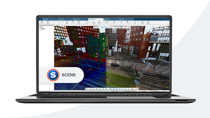
Software FARO® SCENE Software is specifically designed for all FARO scanning solutions and third-party laser scanners. Process and manage scan data efficiently and easily by using automatic target recognition, scan registration and validation.

Generate high-quality data in full color quickly and conveniently by incorporating images from automated targetless and target-based scan positioning. Use Interactive scan registration for a more intuitive visual representation of automatic registration results.

With Hybrid registration, integrate survey control points with cloud-to-cloud registration. Users can begin the evaluation and processing immediately by performing simple measurements, creating stunning 3D visualizations or exporting to various point cloud and CAD formats once SCENE has prepared the scan data. In addition, SCENE features an impressive Virtual Reality (VR) View, allowing users to experience and evaluate captured data in the VR environment.

Tech Sheet
Architecture, Engineering & Construction
Public Safety Analytics
As-Built Capture & Modeling
Construction Prefabrication
Construction Quality Control
Design Layout & Projection
Digital Twin for Asset & Facility Management
Historical Preservation
Crash Reconstruction
Crime Scene Investigation
Arson Investigation
Court Presentation
Safety Planning
Failure Investigation
Architecture, Engineering, Construction
Defense
Education
Fire and Rescue
Forensic Engineering
Geospatial
Insurance
Law Enforcement
Measurement Service Providers
SCENE
Surveying & Measurement
Consideration
Software - Architecture, Engineering & Construction

Subscribe to our newsletter to stay up to date.

Related Content

Filters

Filters

ARTICLE

Reality Capture Technology: Choosing the Best Solution for You

Explore FARO's reality capture solutions to determine which option aligns with your business goals for the best return on investment.
ARTICLE

Surveying Equipment and Technologies for Accurate Measurement

From traditional land boundary surveys to advanced geospatial mapping, today’s surveying equipment reflects decades of evolution, all aimed at improving accuracy, efficiency, and data integrity.
WEBINAR RECORDING

From Site to Insights, in a Blink

Watch how the Blink Imaging Laser Scanner makes reality capture as easy as pressing a button.
INFOGRAFICA

Introduzione a Blink

Guarda l'infografica per scoprire come Blink rende l'acquisizione e la condivisione dei dati sulla realtà facili come scattare una foto.